Bardstown Road - Phase 2

Safety improvements to Bardstown Road by KYTC: Eastern to Taylorsville

Our state transportation agency is redesigning parts of Bardstown Road from 2026-28 (webpage) along the HDNA neighborhood border to “enhance safety for vulnerable road users” as part of a highway safety grant and state funding. The proposed designs are generally supported by HDNA and they meet the safety needs. This project builds upon the Phase 1 safety improvements initiated in 2022 between Eastern Parkway and Broadway, as well-documented by Friends of Bardstown Road.

Public Survey responses to KYTC are due August 14! See our recommendations and survey link.

Bring Back the Douglass "Loop"!

“We have a habit here of beginning with Plan B, compromising to Plan C, and then wondering why Plan A cities keep kicking our butts.”Ken Herndon, councilperson

“The roundabout option is WAY better than the alternative, not even close. Build the roundabout! 😉” – Andy Boenau, author

“I agree with the loop for the Loop.”Paul Downs, resident

We fully support the roundabout option as a bold entrance to the Highlands and a gateway into the historic Douglass neighborhood!

It meets our priorities of adding on street parking, improving walking along and crossing the road, and slowing car drivers to the speed limit. Read our survey recommendations.

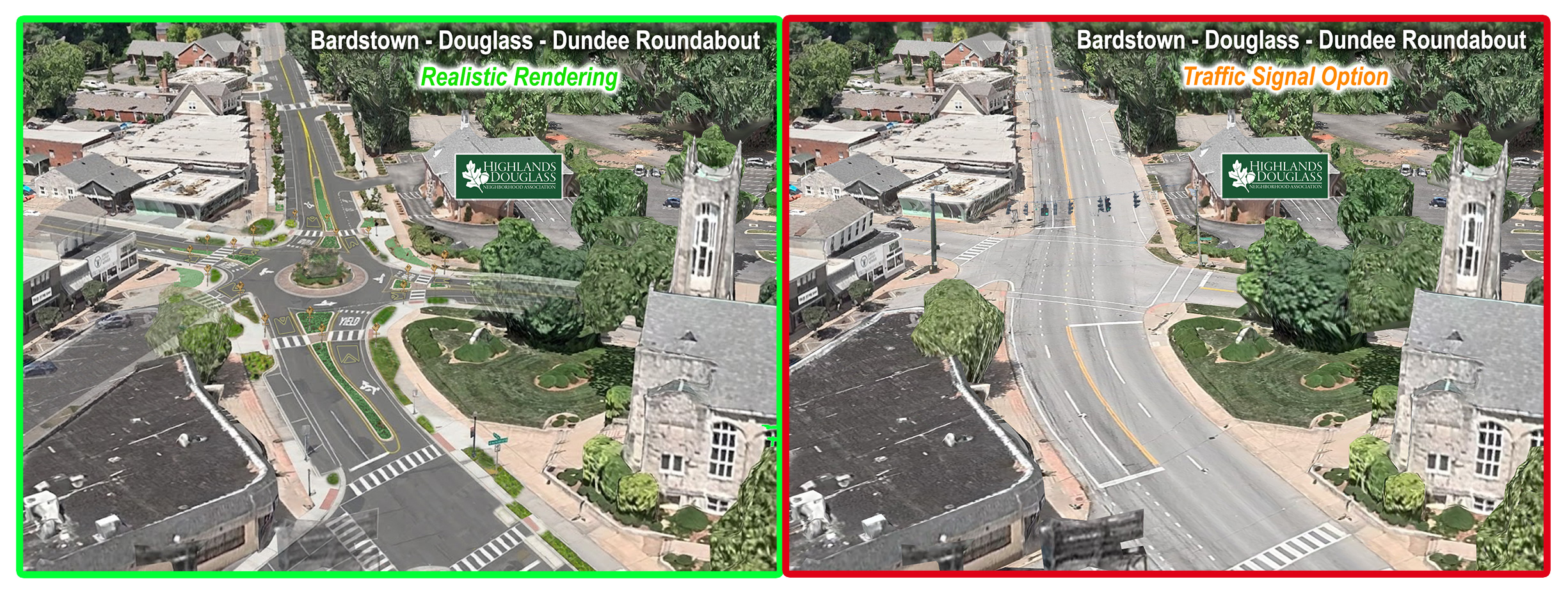
Bold roundabout with greenspace
Bold roundabout, entrance to the Highlands. Cars coming only 1 way and 1 lane to cross. You only need one driver to stop. More green space.

Example of an equivalent roundabout before and after, but the Douglass one would have better crosswalks. See below for details.

Same old same old
Same old intersection, the status quo. Cars coming from many ways, even at a red light with walk signal. Hard and dangerous to cross.

HDNA Recommendations

KYTC has a public survey ✍️open until August 14, 2026. Here are specific HDNA survey recommendations to make Bardstown Road the safest and most vibrant it can be for our residents and visitors, elderly and children, shop and home owners, while also aligning with our neighborhood plan. 

Here are our survey recommendations, for each of the 6 parts of the survey (A to F), including what we love and what we need to see changed!

Copy ✂️ and paste 📝 these comments if you’d like for each question!

A: Eastern Parkway to Bonnycastle Avenue

Support Option A2, with the following comments:

+ Love making the crossings shorter at Eastern.

+ Love adding 9 new on street parking spaces by Qdoba and Seviche.

+ Love in lane TARC stops allowing more parking, like at Baringer and Bonnycastle.

– Need a mid block crosswalk w/ RRFBs at Stevens.

B: Bonnycastle Avenue to Speed Avenue

Support Option B1, with the following comments:

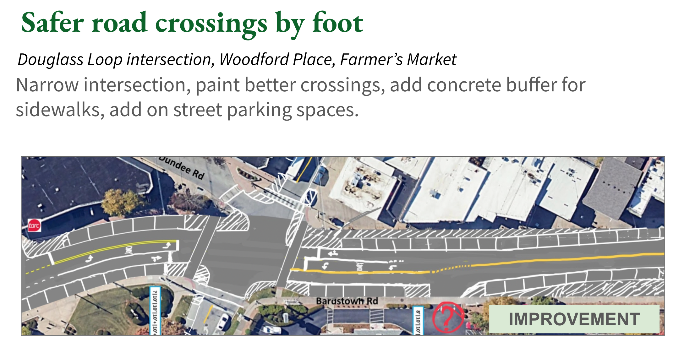
+ Love 2 mid block crossings at Murray and Maryland by the Farmer’s Market.

+ Love concrete around Bonnycastle so drivers don’t hit people walking.

– Need in lane TARC stops like in B2 to add 5 more parking spots.

– Need in lane TARC stop at Ivanhoe for more on street parking.

– Need more concrete at Deerwood and Speed like in B2.

– Need curb cuts at Korean BBQ to be closed for an outdoor patio and more on street parking.

C: Roanoke Avenue to Grasmere Drive

Support Option C1, with the following comments:

+ Love the design, lots of on street parking, and safer sidewalks.

D: Alfresco Place to Harvard Drive

Support Option D10, with the following comments:

+ Love the new intersection at Napolean with large green space and a safe crossing distance for children and church-goers. It makes the 5 way intersection safer and fixes the 120′ current crosswalk. 

+ Love the mid block crossing at Alfresco.

+ Love the in lane TARC stops at Alfresco, creating 8 new parking spots.

+ Love the removal of the center turn lane by Village and Woodford, creating 10 new parking spots on both sides of the street.

+ Love the large new greenspace for trees by Woodford, level driving lanes, and new parking spaces.

+ Love that the roundabout allow crossing one lane of cars each way, instead of crossing 5 lanes at once.

Need at roundabout: wider crosswalks, raised crosswalks on Douglass, rumble strips or speed cushions approaching each crosswalk, low landscaping at all corners and islands, a lighting plan, and 9 stop for pedestrians/ state law signs at each median.

– Need mid-block crossing w/ RRFBs at Woodford for Farmer’s Market and shops.

E: Douglass Boulevard to Wrocklage Avenue

Support Option E5, with the following comments:

+ Love the single lane roundabout with concrete curbs and islands, and flashing lights at each crossing.

+ Love safer crosswalks and driving patterns at Harvard.

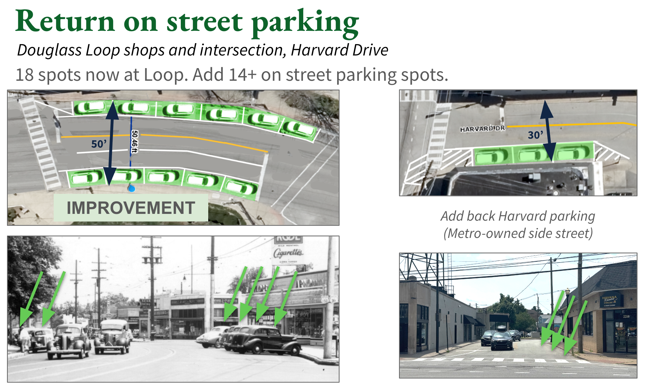
+ Love 6 new parking spots on Harvard.

+ Love in lane TARC stops adding 2 new parking spots and making walking safer.

+ Love parking in front of Graeter’s and Havana Rumba making outdoor dining safer and pleasant.

+ Love the simplified and safer Dorthy and Wrocklage intersection.

– Need curb cuts closed in front of strip malls to add more on street parking.

– Need the E1 concrete curb design at Woodbourne.

– Need a mid block crossing w/ RRFBs at Wrocklage.

F: Wrocklage Avenue to Taylorsville Road

Support Option F6, with the following comments:

+ Love safer intersection at Wrocklage – add dashed lines connecting to lanes across street.

+ Love the mid block crossing by Weber with concrete – much safer location.

+ Love 7 new parking spots by Highland Cleaners.

+ Love dedicated turn lanes at Taylorsville.

– Need in lane TARC stop at Wrocklage for more on street parking.

– Need to add concrete in buffers or widen sidewalks between Weber and Taylorsville on both sides to reduced car speeds and protect sidewalk walkers – this would match the road width of 4 car lanes.

Background and Plans

KYTC Project

This is a project by the state KYTC using a mix of state and federal money for safety improvements and signal upgrades. It includes repaving, new striping, new curbs and sidewalks where needed, curb bump outs, tree and greenery wells, and new traffic signals. There was a KYTC public meeting on July 14 at 5pm at the de Paul School. 

Design options at Douglass including a roundabout

As part of the HDNA approved neighborhood plan from 2006, the Board, resident community, Louisville Metro, and Metro Council recommended:

  1. forming “better connections to Bardstown Road by constructing transportation nodes
  2. analyzing the “intersection at Bardstown Road and Taylorsville for pedestrian safety issues
  3. Reconfigure the intersection at Bardstown Road and Dorothy/Wrocklage Avenue
  4. Create a gateway (much like on Douglass Blvd.) to neighborhood at the aforementioned intersection
  5. ensure that adequate parking is appropriately placed and provided

The Bardstown Road corridor and the neighborhoods immediately adjacent are the most economically productive area in the city and the state, generating more tax revenue than any other neighborhood. The urban street runs through vibrant commercial, residential, and recreational areas in some of Louisville’s best historic neighborhoods.

The 2018 Bardstown Road Safety Study identified this corridor as having one of the highest concentrations of pedestrian crashes in the city. In the last 4 years there were more than 240 excess expected crashes from Taylorsville Road to Bonnycastle Avenue. Work is progressing now to evaluate corridor performance, study improvements, present alternatives, develop plans for construction, construct pedestrian access improvements, and perform traffic signal modernization.

Timeline

  • Summer 2025 – public feedback and restriping
  • Jan-Mar 2026 – public feedback on current issues
  • July 2026 – public meeting
  • 2026 – public feedback on designs
  • 2027 – construction plan and vendor selection
  • 2028 – work started and completed

HDNA Priorities

  1. Keep & add on street parking
  2. Improve, add & shorten road crosswalks
  3. Slow drivers to speed limit

Douglass and Bardstown is the most dangerous intersection in our entire neighborhood. See report and map.

HDNA Priorities

1. Keep & add on street parking

Add on street parking
Parking used to exist in front of Graeter's and St Paul's Church and on Harvard. Return parking along the corridor to help businesses and improve safety for people walking and dining on sidewalks.

There are many places where on street parking has been removed from Bardstown Road to accommodate things like too many driving lanes, wide and long center turn lanes, and bus pull-offs that are not in-lane. 

With sidewalks that are dangerous to walk on (fast cars nearby, no grass buffer, too many curb cuts), road crossings that are too long, or unsafe outdoor seating (with no buffer for cars), adding on street parking addresses all of these concerns, and helps local businesses and residents too.

2. Improve, add, & shorten crosswalks

Shorten crossing distances
Reduce the length of crossings by reducing driving lanes, adding concrete, and widening sidewalk areas.

As a vibrant walkable corridor, residents and visitors cross Bardstown Road and side streets in great numbers, whether they arrive by foot, bike, bus, or car. 

Some crossings require navigating 6 lanes of fast car traffic coming from different directions, or side street crossings of 120 feet, or dealing with complex intersections.

Reducing travel lanes, adding on street parking, creating concrete curb bump outs and refuge islands, and adding new mid block crossings with flashing lights will make this road safer for everyone.

3. Slow drivers to the speed limit

Single Lane Roundabouts
Reduce traffic to one lane in each direction, and slow drivers by narrowing lane widths and adding concrete.

Many parts of Bardstown Road are designed like a highway, with up to 6 lanes for cars which encourages speeding, jockeying for positions, and darting around turning drivers, which endangers everyone.

Reducing the number of travel lanes to 2 and adding lots of concrete bump outs, greenery, trees, and on street parking (like north of Bonnycastle from Phase 1) will help slow drivers to the speed limit and reduce road racing. 

More creative, bold solutions like roundabouts, combining complex side roads, and large green curb areas can make our streets more pleasant and safer.

Support for the Roundabout

For this roundabout, in this situation, at this location, with this design, we think it’s a superior option to keeping 5 driving lanes through the large intersection.

We fully support the roundabout option as a bold entrance to the Highlands and a gateway into the historic Douglass neighborhood!

It meets our priorities of adding on street parking, improving walking along and crossing the road, and slowing car drivers to the speed limit. Read our survey recommendations.

Here’s why we like it better than the alternative:

  1. It’s a bold gateway to our neighborhood and the Highlands
  2. There is only a single driving lane from each direction
  3. All drivers approach the (some raised) crosswalks at a safer 90 degrees
  4. Speeds are expected to be 20-25mph through it
  5. There is concrete narrowing the lanes, curbs, and turns, and islands at each approach
  6. It adds 5 parking spaces in front of Graeter’s and Havana Rumba
  7. It adds a huge sidewalk and greenspace area between Woodford and Douglass
  8. Greenspace and trees can be added in the new concrete areas and circle center
  9. Each crosswalk has RRFB flashing light buttons, like at Edenside
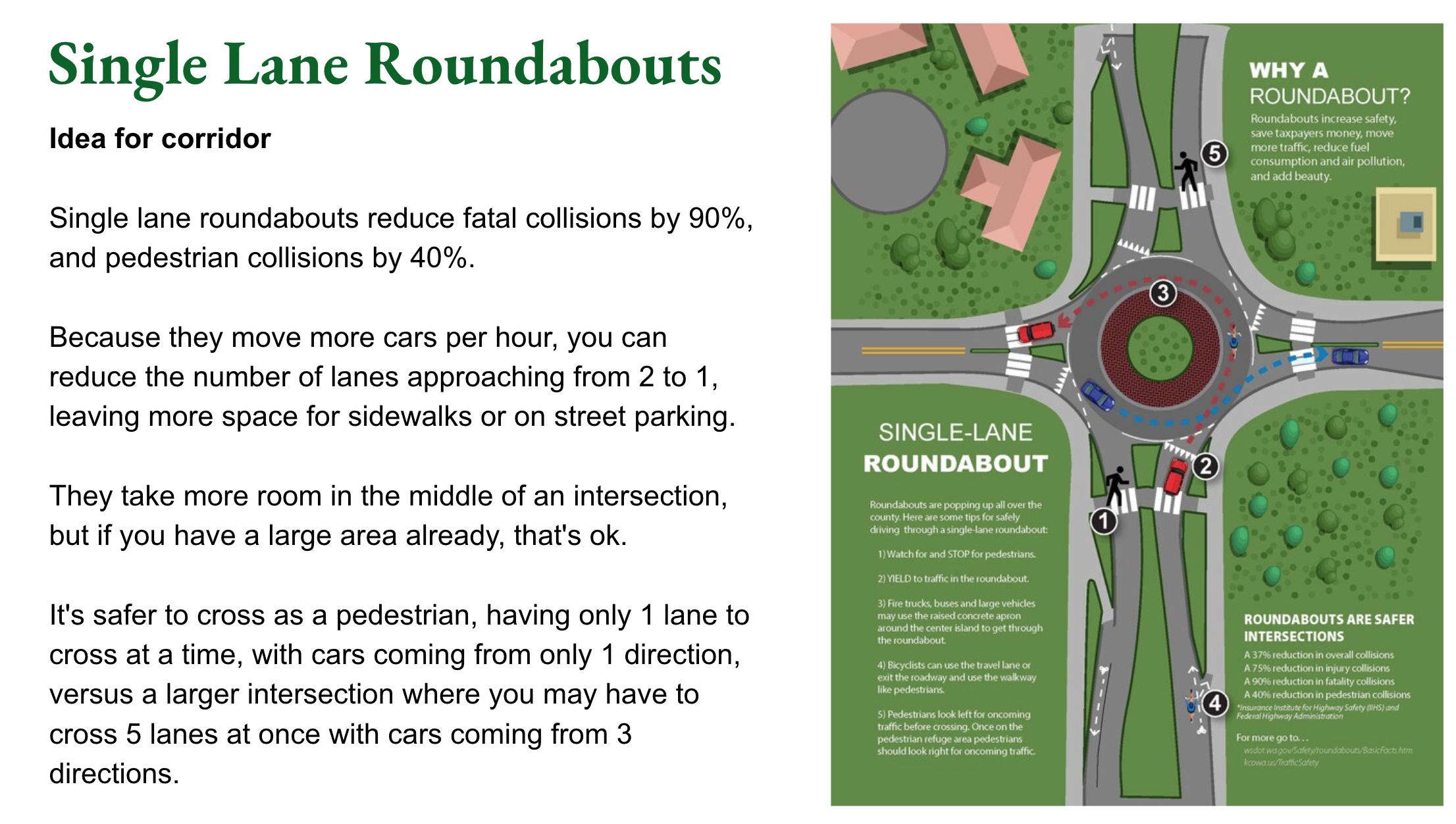
  10. Pedestrians only have to cross and look at one lane at a time when crossing, instead of 4-5 lanes and 3+ car approaches
  11. You only need one car to stop for a pedestrian for them to cross
  12. It slows drivers and signals for them to slow down
  13. It reduces taxpayer cost and maintenance because the traffic signals are removed
  14. It keeps it one driving lane each way, east to Harvard and west to Woodford, allowing more on street parking
  15. It eliminates the center turn lane from Douglass to Village, allowing more on street parking
  16. It adds on street parking from Woodford to Village, protecting the sidewalk, and for our Farmer’s Market
  17. Walking a circle around all the crosswalks is only 25% longer, but you cross 9 lanes, 1 at a time — versus 16 lanes, 4-5 at at time
  18. Traffic signal poles and wires are removed for clear sky views, and new room on each corner for greenery

The other design doesn’t do any of this, and is basically the same as it is now, defining 4-5 driving lanes on Bardstown and keeping the center turn lanes through Village and Harvard. It is currently an uncomfortable and dangerous experience here for anyone crossing or walking to shops, including people headed to Lakeside or Douglass Loop, children, families, the elderly, visitors, residents, and others walking or biking through.

KYTC Experience

KYTC has said that the roundabout can handle car traffic volumes better than the current design, emergency vehicles and fire trucks can navigate the circle easily with the mountable center curb, and that roundabouts are safer for drivers and walkers for many reasons.

KYTC has implemented 41 single lane roundabouts, and another 21 larger or smaller roundabouts in Kentucky already, with at least 6 others in the works. They understand how Kentuckians use them, what traffic flow is like, what is appropriate where, how first responders can use them safely, how they reduce crashes and injuries for everyone, and how to build and maintain them. See their web page and dashboard.  From their website:

Crashes at intersections account for about 45% of all crashes nationwide, so enhancing the vehicle flow at these junctures is critical to reducing the risk of overall crashes. Roundabouts are a proven safety countermeasure to accomplish this goal. In communities where roundabouts have replaced traditional intersections, crash statistics show dramatic drops:
    • 37 % reduction in all crashes
    • 90 % reduction in fatal crashes
    • 75 % reduction in injury crashes
    • 40 % reduction in pedestrian injuries
In addition to safety, roundabouts are an effective and beneficial intersection design because they:
    • Save Time by streamlining vehicle movement during peak traffic hours and other times. Because traffic is continuous, drivers experience fewer stops, shorter delays and less congestion.
    • Improve Access to Businesses or Organizations on the opposite side of the road by eliminating risky left turns and prohibiting vehicles from cutting across oncoming traffic. Instead, drivers safely and easily travel counterclockwise in the roundabout, and exit to their destination via a right turn.
    • Reduce Pollution and Fuel Use because drivers make fewer stops followed by hard accelerations and spend less time idling. Motorists aren’t wasting fuel and adding more emissions to the environment like a vehicle stopped at a traffic signal.
    • Save Taxpayer Dollars since there is no traffic signal equipment to install, power and maintain.
    • Promote Community Livability, Beauty, and Comfort by providing quieter corridors, fewer obtrusive traffic signals, and the ability to create a green space in the central island.

Our community and neighborhood should support visionary and transformative projects like this roundabout, for the safety and vitality of our people and businesses!

Safety and Size

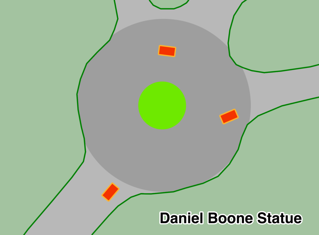
The roundabout will be compact, the right size for the neighborhood, maximizing safety for everyone, especially pedestrians. See its size relative to other nearby roundabouts. 

Daniel boone footprint
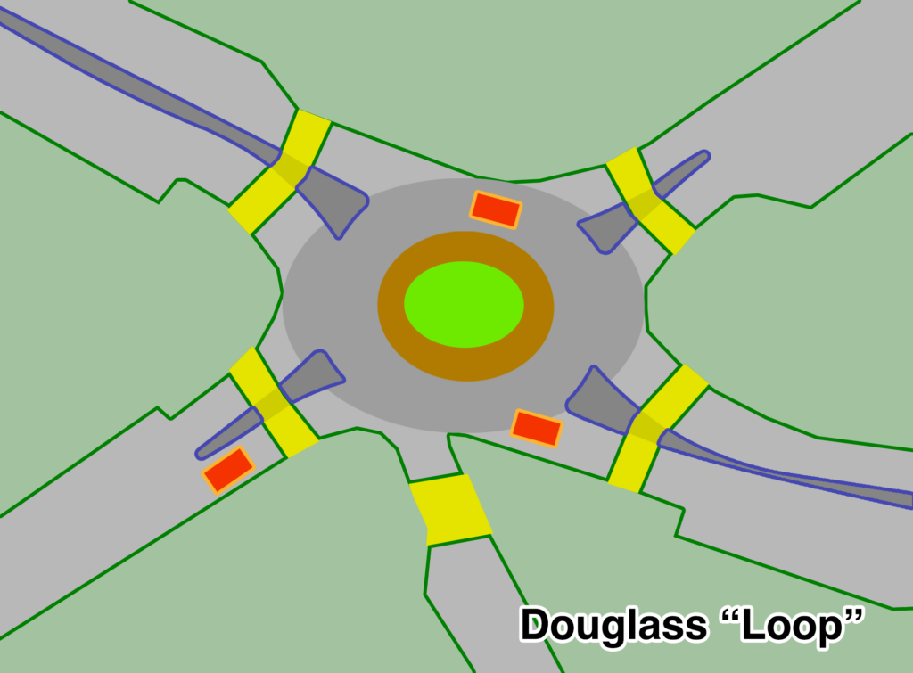
douglass loop footprint
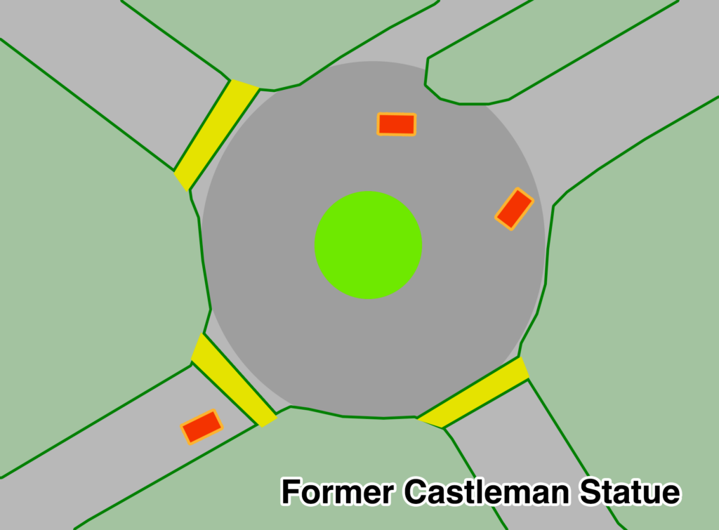
former castleman footprint

How big is It?

Smaller footprint than the Daniel Boone and Castleman roundabouts, which are pretty over-sized for what they are. 

The Douglass Roundabout will have half of the surface area, with many more crosswalks (each with flashing lights), some raised, and more signage. 

It’s the right size for both drivers and walkers, allowing more car traffic flow with 50% less delay than the traffic light option.

Is it safe to walk across?

  • Will have 9 crosswalks, one lane each. 
  • Each gets button activated flashing beacons, crosswalk and yield signs. 
  • Similar to Edenside crosswalk, but half the lanes and much slower car drivers. 
  • Less distance and lanes to cross than the Daniel Boone and Castleman roundabouts.
  • Cars moving about the same speeds in all three: 20-25 mph.
  • We do want rumble strips or speed cushions, more raised crosswalks, and “stop for pedestrians” signs added – put that in your survey response!
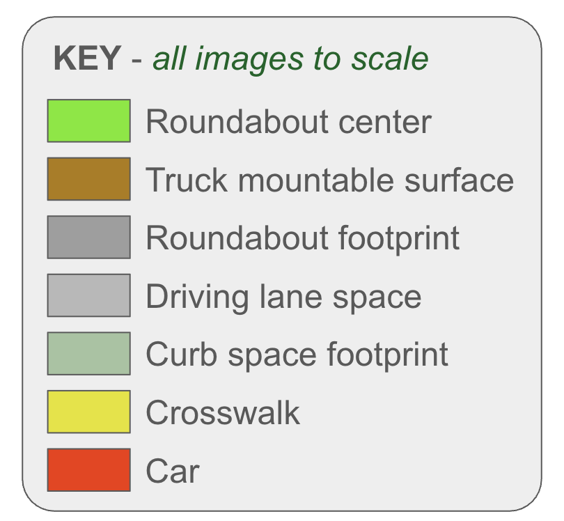
Size Key

What Could a Roundabout Look Like?

Want to see what the Douglass Roundabout could look like, and how it will be good? This La Jolla Blvd roundabout in San Diego is very equivalent to the urban density, traffic volumes, size, current road features, residential/commercial area, and proposed KYTC roundabout design at Douglass.

Read a detailed report 📄 and a case study 🔍 on this roundabout, and see some images and some outcomes below. And a street view video 🎥 of the design.

“Slow traffic speeds and provides inviting gateway to the neighborhood.”

– The traffic count remained approximately the same (23,000 vehicles per day before, 22,000 after)

– Speeds were reduced from 40–45 mph to 19 mph

– Retail sales rose 30 percent

– Noise levels dropped 77 percent

– Traffic incidents and crashes have dropped by 90%

– Greatly enhanced safety for pedestrian crossing

The community was only 30% in favor before it was built, but jumped to 70% a year later!

Neighborhood Associations

Contact the neighborhood associations that touch this project, and ask them to voice support, fill out the survey, publish a web page, and email residents with their own recommendations: